Hi,
I am using RFEM 6.12.0012 (I had the same issue on 6.12.0010 so I updated but it didn’t fix it, I also note that the api is only on 2.12.11 so a slight mismatch but I don’t think it should affect it).
I have sucessfully created a borehole using the api. I am now trying to create a soil massif.
I have been refering these documentation pages:
Borehole — Dlubal API documentation
SoilMassif — Dlubal API documentation
Solid — Dlubal API documentation
To create the borehole I have:
def build_borehole_object(tc_no: str, crane_setout_point: Tuple[float, float, float], slab_mid_z: float,
						  geotech_data: Dict[str, Any], strata_material_map: Dict[int, int], no: int = 100) -> Any:
	"""Build a single RFEM borehole object at the crane setout point.

	The borehole layers start from the slab mid Z: the first layer starts
	at slab_mid_z and extends down to the first strata bottom RL; subsequent
	layers use top_rl - bottom_rl for thickness.
	"""
	name = f"{tc_no} Borehole"
	x, y, _ = crane_setout_point
	ground_water_rl = geotech_data.get("ground_water_rl")
	table = geotech_data.get("ground_data_table") or []

	layers = []
	started = False
	for i, strata in enumerate(table):
		top_rl = strata.get("top_rl")
		bottom_rl = strata.get("bottom_rl")
		if top_rl is None or bottom_rl is None:
			continue

		if (not started) and (slab_mid_z <= top_rl and slab_mid_z >= bottom_rl):
			thickness = float(slab_mid_z) - float(bottom_rl)
			started = True
		elif started:
			thickness = float(top_rl) - float(bottom_rl)
		else:
			continue

		mat_no = strata_material_map.get(i)
		row_no = len(layers) + 1
		layer_row = rfem.geotechnical_analysis.Borehole.LayersTableRow(
			no=row_no,
			description=str(strata.get("strata") or ""),
			layer_no=row_no,
			soil_material=mat_no or 0,
			depth=thickness,
			bottom_ordinate=float(bottom_rl),
		)
		layers.append(layer_row)

	layers_table = rfem.geotechnical_analysis.Borehole.LayersTable(rows=layers)
	borehole = rfem.geotechnical_analysis.Borehole(
		no=no,
		type=rfem.geotechnical_analysis.Borehole.TYPE_STANDARD,
		name=name,
		user_defined_name_enabled=True,
		coordinates=common.Vector3d(x=float(x), y=float(y), z=float(slab_mid_z)),
		groundwater=True if ground_water_rl is not None else False,
		groundwater_ordinate=float(ground_water_rl) if ground_water_rl is not None else 0.0,
		layers_table=layers_table,
		comment="Created from geotechnical table"
	)

	return borehole
This works well.
To create the soil massif I have:
# Hardcoded soil massif size (meters)
SIZE_X = 100.0
SIZE_Y = 100.0

def build_soil_massif(tc_no: str, crane_setout_point: Tuple[float, float, float], slab_mid_z: float,
					  geotech_data: Dict[str, Any], borehole_no: int) -> Any:
	"""Build a SoilMassif object centered on the crane setout / borehole.

	The SoilMassif is configured per the user's spec: fixed size, rectangle
	topology, groundwater enabled, assigned to the provided borehole, and
	using FEM analysis.
	"""
	x, y, _ = crane_setout_point

	soil_massif = rfem.geotechnical_analysis.SoilMassif(
		type = rfem.geotechnical_analysis.SoilMassif.TYPE_STANDARD,
		user_defined_name_enabled=True,
		name=f"{tc_no} Soil Massif",
		assigned_to_type=rfem.geotechnical_analysis.SoilMassif.ASSIGNED_TO_TYPE_BOREHOLES,
		assigned_to_boreholes=[int(borehole_no)],
		topology_type=rfem.geotechnical_analysis.SoilMassif.TOPOLOGY_TYPE_RECTANGLE,
		analysis_type=rfem.geotechnical_analysis.SoilMassif.ANALYSIS_TYPE_FINITE_ELEMENT_METHOD,
		depth_according_to_boreholes=True,
		center_x=float(x),
		center_y=float(y),
		size_x=SIZE_X,
		size_y=SIZE_Y,
		rotation_about_z=0.0,
		groundwater=True,
		comment="Auto-generated soil massif from geotechnical table",
	)
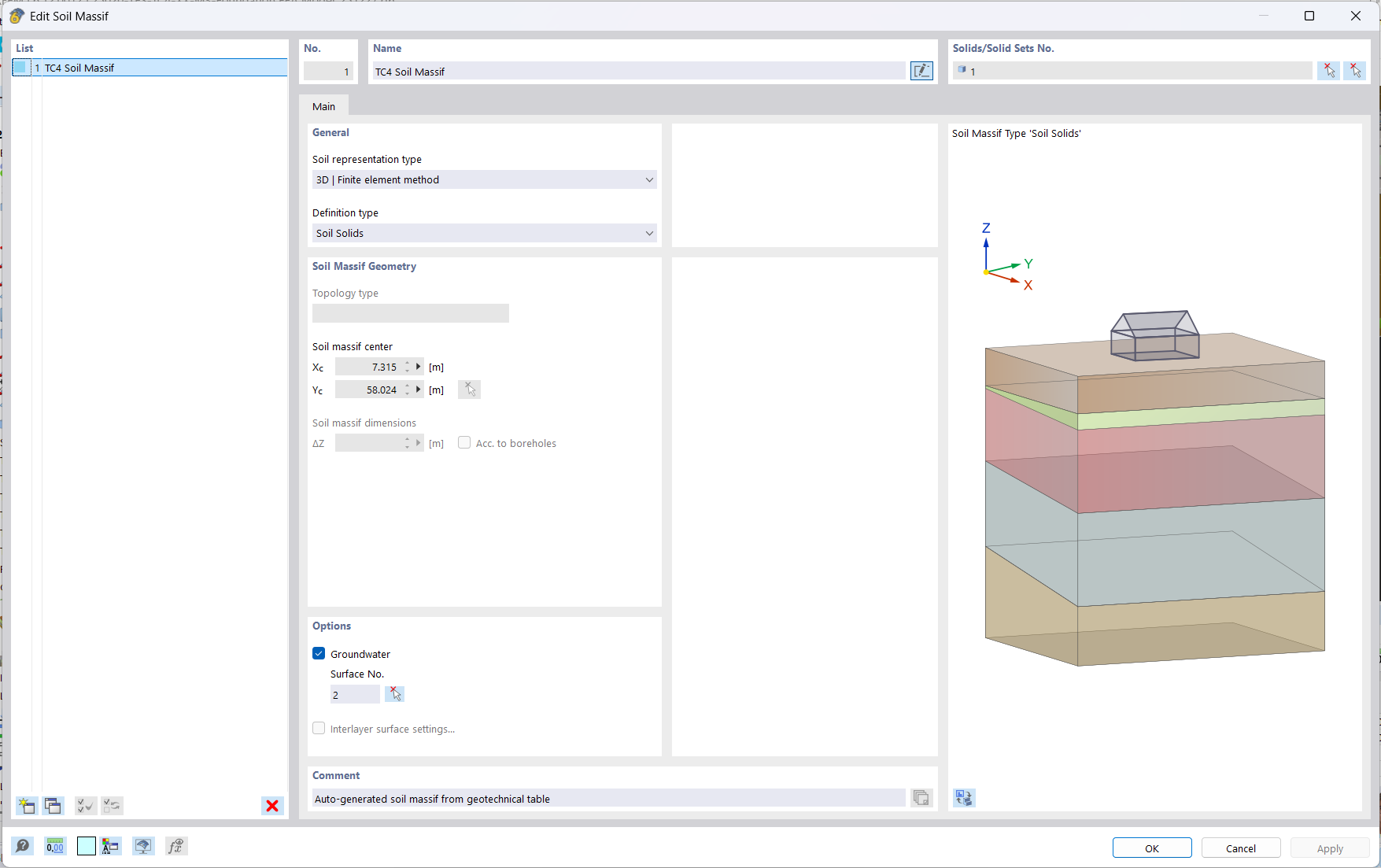
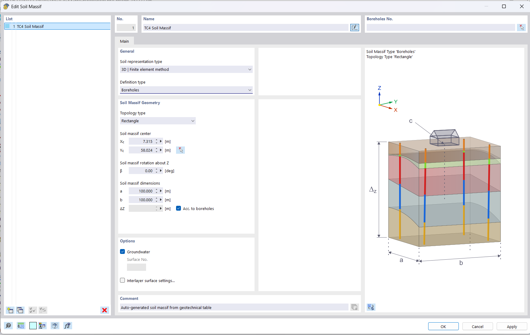
But when I go into the RFEM6 UI, it has definition type = Soil Solids (I want it to be Boreholes). I assumed that assigned_to_type=RFEM.geotechnical_analysis.SoilMassif.ASSIGNED_TO_TYPE_BOREHOLESwould have made it Boreholes?
When I change to Boreholes, all the info that I had from my api command seems to be saved (ie the size, but not the Borehole No., although from my log I know its using the correct borehole number).
When I change it to have type = TYPE_PHANTOM (as shown below)
soil_massif = rfem.geotechnical_analysis.SoilMassif(
		type = rfem.geotechnical_analysis.SoilMassif.TYPE_PHANTOM,
		user_defined_name_enabled=True,
		name=f"{tc_no} Soil Massif",
		assigned_to_type=rfem.geotechnical_analysis.SoilMassif.ASSIGNED_TO_TYPE_BOREHOLES,
		assigned_to_boreholes=[int(borehole_no)],
		topology_type=rfem.geotechnical_analysis.SoilMassif.TOPOLOGY_TYPE_RECTANGLE,
		analysis_type=rfem.geotechnical_analysis.SoilMassif.ANALYSIS_TYPE_FINITE_ELEMENT_METHOD,
		depth_according_to_boreholes=True,
		center_x=float(x),
		center_y=float(y),
		size_x=SIZE_X,
		size_y=SIZE_Y,
		groundwater=True,
		comment="Auto-generated soil massif from geotechnical table",
	)
It becomes Definition Type = Borehole in the UI but the code stops as I get this error (I am not sure what PHANTOM is, but I assume it means its like a placeholder and not used in the FEA so it should be STANDARD?
2025-12-27 13:48:42 [ERROR] infrastructure.rfem_api.foundation.rfem6_foundation - Error in foundation model creation: <_InactiveRpcError of RPC that terminated with:
	status = StatusCode.UNKNOWN
	details = "Failed to create Soil Massif No. 1.  Attribute 'type' or the attribute on which it depends is invalid or incorrectly defined: Invalid object type.
"
	debug_error_string = "UNKNOWN:Error received from peer  {created_time:"2025-12-27T06:48:42.359344+00:00", grpc_status:2, grpc_message:"Failed to create Soil Massif No. 1.  Attribute \'type\' or the attribute on which it depends is invalid or incorrectly defined: Invalid object type.\n"}"
>
There’s no examples of the geotechnical analysis with the API and couldn’t find any related topics on the forum so I was hoping someone could help me out with what I am doing wrong ![]()
When I create it manually and export to python the soil massif doesn’t show up so I couldn’t figure out what the correct api code is that way ![]()
Update:
I realised that it was auto changing to be Definition Type: Soil Solids once I edit the created solid to have my surface as an integrated object (as when I commented out this code the soil massif definition type was Borehole). I guess there is no issue with it changing to soil solids.
My new issue is that while it calculates when the soil massif is 30 x 30 meters, it doesn’t calculate for 100 x 100 meters? Could I send my model privately to someone from dlubal to check out why?
Thanks,
Samuel